
MiBSAR's home page
13-day Tip Top Mountain Expedition and
White Gravel Canyon Bush Plane Crash SAR Operation
July 31 to August 12, 2011
Pukaskwa National Park
Thunder Bay District
Marathon, Ontario, Canada
|
09-13-10 Notice: This SAR operation has been postponed pending further research on wreckage found in 2005. |
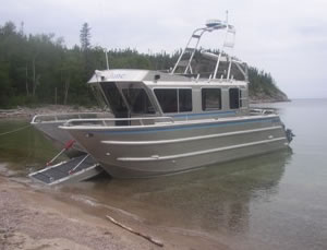 |
| We'll be chartering the 30-foot, catamaran (twin hulls) landing craft pictured above for our insertion and extraction, hopefully at the mouth of the White Gravel River and in White Spruce Harbor, respectively. Captained by Keith McCuaig of McCuaig Marine Services in Marathon (mccuaigmarine@shaw.ca, 807-229-0193), it's capable of transporting 12 passengers and rucks. Custom-built in 2008 by Armstrong Marine, Inc., in Port Angeles, Washington, the catamaran has an electric-hydraulic ramp and is powered by twin gas outboards—4-cycle Yamaha 250s. |
 |
|
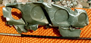
The above plane wreckage was found in White Gravel Canyon in a remote part of Pukaskwa National Park during a 2005 Canadian backpacking expedition. Click here to read more about this investigation. (Photo courtesy of Mary Powell) |
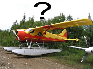 |
| The wing cross-section, including an intact rib, is likely from a small bush plane, perhaps one similar to the deHavilland Canada DHC-2 Beaver pictured above. Click here to read more about this investigation. |
MiBSAR's late-summer 2011 Canadian Backpacking Expedition has been set for July 31 to August 12.
This 13-day, 40-klick (kilometer) expedition will involve MiBSAR's first attempt at summitting Tip Top Mountain, an outcrop regarded as the pinnacle of Ontario from its discovery in 1899 until improved cartographic techniques pushed it off its top spot 1967.
The later half of this expedition will involve a SAR field operation in White Gravel Canyon. We'll be searching for a unknown, hidden crash site that is likely the source of a piece of plane wreckage found further downstream on a 2005 expedition. Click here to read more about this wreck.
Estimated per-person costs:
Park entry and camping fees—$100
Round-trip landing-craft fees—equal share of $1,400
Tentative Itinerary:
July 30 Sat — Travel to Voyageurs Inn and Cookhouse in Batchawana Bay, Ontario July 31 Sun 1 Drive to Pukaskwa National Park; register in afternoon; board chartered landing craft in early evening; bivouac along Lake Superior Shoreline after insertion near mouth of White Gravel River Aug 1
Mon 2 Cache backup food stores in case landing craft is delayed by heavy seas during extraction. Work our way up river in South White Gravel Canyon Aug 2 Tue 3 Work our way up river in South White Gravel Canyon Aug 3 Wed 4 Cache expedition food stores; depart South White Gravel Canyon and bushwhack south to summit Tip Top Mountain; bivouac on summit Aug 4 Thur 5 Flex day Aug 5 Fri 6 Depart summit of Tip Top Mountain and bushwhack north, returning to South White Gravel Canyon to pick up expedition food stores cache Aug 6 Sat 7 Depart South White Gravel Canyon and bushwhack north, dropping into White Gravel Canyon, where our SAR operation for bush plane crash site will begin Aug 7 Sun 8 Work downstream in White Gravel Canyon in search of bush plane crash site Aug 8 Mon 9 Work downstream in White Gravel Canyon in search of bush plane crash site Aug 9 Tue 10 Flex day Aug 10 Wed 11 Work downstream in White Gravel Canyon in search of bush plane crash; arrive at Lake Superior Aug 11 Thur 12 Hike coastal trail south to White Spruce Harbor Aug 12 Fri 13 Early-morning extraction by chartered landing craft in White Spruce Harbor Aug 13 Sat — Travel or backup day Aug 14 Sun — Travel or backup day
Further details about this expedition and SAR field operation will be posted on this page as they become available.
Last revised on 07-16-10