
You're here: MiBSAR's home page :: SAR operations log page :: SAR op photo-journal page
Michigan
Backcountry Search and Rescue (MiBSAR)
SAR Op No. 3 photo-journal:
Joe Clewley missing-person investigation
By
Michael Neiger
Marquette, Michigan
© Copyright 2008
Duration & date: Agency assisted:
_____________________
Sault Ste. Marie, MichiganTownship & County: Nearest place-name: General location: Tahquamenon Falls State Park in the eastern Upper Peninsula Trail: Victim: Joseph Robert Clewley
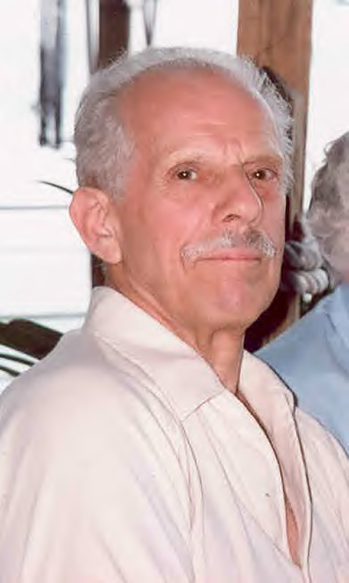
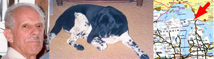
White male; age 73; 5'-10"; 150 lbsCase summary: Joe Clewley and his dog Chip went missing on July 13, 2008. His van was found parked at the North Country Trail (NCT) trailhead along the Tahqua Trail in the eastern reaches of Tahquamenon Falls State Park. Joe owned a log cabin in the area and enjoyed hiking off-trail in the park. SAR op mission: MiBSAR team members: Partner SAR teams & assets: SAR op results: Joe Clewley was not located Additional resources: • Learn more about this investigation
• View official, Sheriff's Office-provided Web site for victim
• View MiBSAR-provided Web site and Internet blog for victim
Friday, August 8
Sweeping the Tahquamenon's north bank
It was sunny and warm for the start of the Michigan Backcountry Search and Rescue (MiBSAR) Search Op No. 3 for Joseph Clewley. This 3-day search effort would be a water-based search of the Tahquamenon River and the channels and floodings of the upper west and main branches of Lynch Creek.
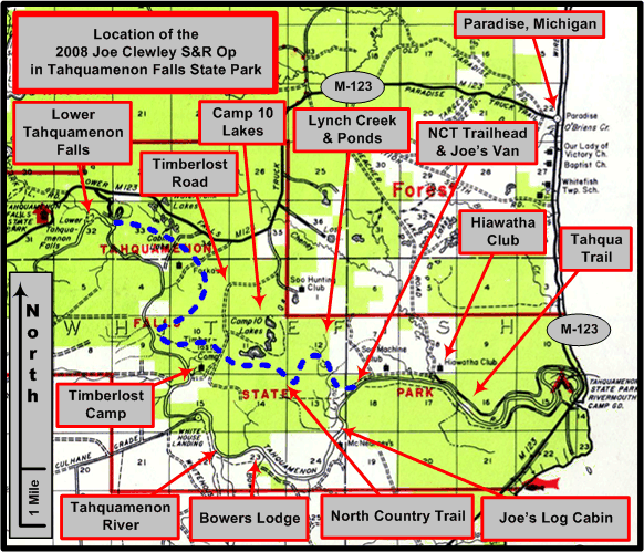
An overview of the Joe Clewley search area in the eastern Upper Peninsula of Michigan, southwest of Paradise, in the Tahquamenon Falls State Park. (Graphic by Michael Neiger)
After launching my canoe at the mouth of the Tahquamenon River along the shore of Lake Superiors Whitefish Bay, I began paddling upstream, combing the waterline along the rivers north bank for any sign or evidence of the whereabouts of Joe Clewley.

The search began at the mouth of the Tahqaumenon River on Lake Superior's Whitefish Bay. (Photo by Michael Neiger)
As I paddled into a small backwater--adjacent to Emerson peninsula, a beautiful sandy spit--I jumped a number of ducks and geese from this marshy area. I spotted three turtles sunning themselves on a floating timber among the lily pads.
Water lillies in a backwater along the north bank of the Tahquamenon River, just upstream from Whitefish Bay. (Photo by Michael Neiger)
A painted turtle in a backwater along the north bank of the Tahquamenon River, just upstream from Whitefish Bay. (Photo by Michael Neiger)
Once clear of Emerson Peninsula, I paddled under the M-123 bridge and continued working my way up the Tahquamenons north bank, which consisted of thick grass and brush right down to the waterline.
The north bank of the Tahquamenon River near M-123. (Photo by Michael Neiger)
Shortly after the riverbank departed westward from M-123, I observed a number of old vessels scuttled in an area sandwiched between the waterline and Tahqua Trail, which traced its way westward along the riverbank.
The 35-foot Oran, a huge, doubled-end aluminum skiff found scuttled along the north bank of the Tahquamenon River, not far upstream from M-123. (Photo by Michael Neiger)
An old, 24-foot, wooden hulled vessel--registration no. 38B1493--with an inline V-8 found scuttled along the north bank of the Tahquamenon, not far upstream from the Oran. (Photo by Michael Neiger)
A 12-foot steel-hulled dinghy found scuttled along the north bank of the Tahquamenon River, not far upstream of the 24-footer and the Oran. (Photo by Michael Neiger)
After checking the margins and inlets of a very large marshy island near the rivermouth, I continued paddling upstream along the north bank. From time to time I would examine sweepers, strainers, deadheads, and logjams for any evidence of Joe Clewleys whereabouts.
Inspecting one the many log jams along the Tahquaenon River for evidence of the whereabouts of Joe Clewley. (Photo by Michael Neiger)
Late in the afternoon, storm clouds began to move in, signaling an impending change in the warm and pleasant weather I had experienced up to this point.
Storms coming in over Joe's Country on the Tahquamenon River. (Photo by Michael Neiger)
As evening began to set in, I established my night bivouac on a sandy, pine-studded point adjacent to an unnamed tributary along the south bank of the river. As darkness arrived so did the biting insects, primarily mosquitoes. I applied some DEET and lit a smug-producing bug coil. Relaxing in Joes Country, I wondered just where the woodsman was at that very moment. During the night, I awoke several times to the sound of rain on my tarp.


Saturday, August
9
Sweeping the Tahquamenon's north and
south banks
When I arose in the morning, enough rain had collected in my 14-foot Mohawk Challenger that I had to flip it over to empty it.
After a cup of hot chocolate and a billy full of granola, nuts, and dried raspberries, I slipped my canoe back in the Tahquamenons slight current, paddled across the river, and continued combing the north bank for evidence.
Having paddling past what was locally know as Snug Harbor, a cluster of seasonal cottages and camps, I encountered a navigable tributary of the Tahquamenon River: Cheney Creek. This creek drains a large swamp located along the north side of M-123, several miles north of the Tahquamenon. Cheney also flows through large tracts of land owned by the Hiawatha Hunt Club, located just to the north of the Tahqua Trail.
Paddling up the navigable, lower limits of Cheney Creek, a tributary of the Tahqaumenon River that is located 2.5 miles downstream from the Clewley log cabin. (Photo by Michael Neiger)
After paddling as far up Cheney Creek as I could--a relatively short distance due to a log jam--I returned its confluence with the Tahqaumenon to take a short break.
Taking a break at the confluence of Cheney Creek with the Tahquamenon River. (Photo by Michael Neiger)
About 0.5 miles downstream of Joe Clewleys log cabin, I came to the mouth of Lynch Creek. This tributary drained a large swath of Joes Country, an area he loved to explore with his dog Chip, in search of wildlife-watching opportunities. I paddled up a bit of this slow-flowing, narrow waterway, before turning around when I encountered a logjam.
Paddling up the navigable, lower limits of Lynch Creek, a tributary of the Tahquamenon River. The Clewley log cabin is located 0.5 miles upstream from the mouth of Lynch Creek. (Photo by Michael Neiger)
Just upstream from the confluence of Lynch Creek and the Tahquamenon River, I arrived at Joe Clewleys two-room log cabin. Built in the 1920s, its always been known at the Chippewa Hunting Post. Later in the day, when I interviewed the owners of the Bowers Lodge several miles further upstream, they spoke highly of Joe, and his dog Chip, both of whom always greeted them cheerfully as they passed the Clewley cabin on their way upstream to the Lodge, which was only accessible via the river.
Joe Clewley's piece of paradise in God's Country--the Chippewa Hunting Post--along the north bank of the Tahquamenon River. The Clewley cabin is situated about 7 miles upstream from the mouth of the Tahquamenon River on Lake Superior's Whitefish Bay. (Photo by Michael Neiger)
Just upstream of the Clewley log cabin, which is located about 7 river miles upstream of the mouth of the Tahquamenon River, I spent some time mid-channel, inspecting a long, narrow, shallow area choked with lily pads and floating debris.
Checking a lily pad shallows, mid-channel and just upstream from the Clewley log cabin on the Tahquamenon River, for evidence of Joe Clewley's whereabouts.(Photo by Michael Neiger)
Not far upstream of the mid-channel shallows, I carefully inspected two long, narrow, backwater channels along the north bank. Beyond these, I checked the perimeter of a small island.
I turned around and began scouting the south bank of the Tahquamenon River when I reached the Bower Lodge, immediately north of Bowers Creek. Situated on high point studded with giant, eastern white pines, the vertical-log structures were built in 1926 by a trapper named Bower. I conversed with the owner for some time, asking him questions about his neck of the woods and what he knew of Joe Clewleys habits. As I drifted downstream, I told the very helpful owner to enjoy his bit of Gods Country. He smiled and said he would.
As darkness began to set in, I ended up bivouacking where I had spent the previous night, just downstream and opposite of Snug Harbor. However, with the change in weather--a wind out of the north--it was decidedly cooler and I reached into my rucksack for additional clothing: a couple polypro shirts, a thin insulated jacket, and a hat.
As the sun set over Joes Country, I relaxed and enjoyed a cup of chai tea, followed by a cup of hot chocolate. I imagined he loved this restful spot, overlooking the river like it did. Screened from view, one could unobtrusively watch the comings and goings of the river and its passing wildlife with ease.
Sunset over Joe's Country, as viewed from Snug Harbor, which is situated 3.5 miles downstream from the Clewley log cabin. (Photo by Michael Neiger)


Sunday, August 10
Canoeing the Lynch Creek floodings and
channels
It was cool and very windy when I awoke and ate breakfast. Once my rucks were tied into the bow and stern of my river canoe, I headed downstream to finish searching the remainder of the Tahquamenons south bank. Along the way, I found a fishing pole, buoy marker, and wooden canoe paddle.
At the rivermouth launch site, I loaded everything into my van, lashed on the canoe, and headed for the NCT trailhead along the Tahqua Trail. From the trailhead, I portaged my canoe northward to the Lynch Creek watershed. At the upper west branch of Lynch Creek, I paddled up the navigable flooding and river channel, north of the NCT bridge, inspecting it up to the point where the channel was impounded by logs and weeds.
Canoe portaged along the North Country Trail to check the upper west branch of Lynch Creek from the NCT bridge north to where it is impounded by logs. (Photo by Michael Neiger)
When I arrived back at the main branch of Lynch Creek, I paddled the navigable flooding and channels, both upstream and downstream of the NCT bridge. I paddled downstream to the point where a beaver dam creates a substantial backwater, and paddled upstream to a point where the channel is impounded by weeds.
Canoe portaged along the North Country Trail to check the main branch of Lynch Creek from the NCT bridge, north to where it impounded by weeds, and south to where it is impounded by a beaver dam. (Photo by Michael Neiger)
While nothing noteworthy was learned about the whereabouts of Joeseph Clewley during this three-day MiBSAR search effort, a good portion of the Tahquameon River--from the rivermouth on Whitefish Bay to Bowers Lodge, a distance of some 9.5 river miles--was re-checked for clues. In particular, the area searched included an up-close and personal inspection of:
- 9.5 miles of the north bank of the river
- 9.5 miles of the south bank of the river
- 2 miles of island shoreline
- 1.5 miles of marsh backwater
- numerous mid-channel deadheads
- numerous shoreline sweepers, strainers, and log jams
On the drive back home to Marquette, I began to work on the details for search op no. 4, which would be conducted from August 15-17. My partner, Chris Ozminski, and I were planning on working a high-probability area around the headwaters of the Lynch Creek watershed in sections 7 and 12.
We had previously back-tracked Joes dog Chip to areas south and east of this region, and a K-9 handler from Bay Mills P.D. told us his dog hit on a strong scent during an original search of this area in the days immediately following Joes disappearance.
While several K-9 teams and search teams had worked the Lynch Creek Trail as it cuts this area, much of the remoter, off-trail areas remain unexamined...


Return to top of page :: Return to home page
In God's wilderness
lies the hope of the world,
the great, fresh, unblighted,
unredeemed wilderness.
—
John Muir, 1838-1914
Alaska Wilderness, 1890
If
you've been able to read this Web page...
thank a Teacher;
If you've been able to read this Web page in English...
thank a Veteran.
—Author
unknown
•
Copyright notice •
Content Copyright © 1984 --
2009-09-16
by Michael A. Neiger
• All rights reserved •
No part of this Web page or this Web site protected by copyright law may be reproduced, transmitted, or used in any form--including graphic, electronic, Web, mechanical or other form--or by any means--including photocopying, recording, taping, Internet distribution, information storage retrieval system, or by other means--for any purpose, except by a reviewer, who may quote brief passages, without the prior, express, written permission of the author.
Comments?
Suggestions?
Dead links? Inaccurate info?
Contact the WebMaster, Michael A. Neiger, at mneiger@hotmail.com
Web site URL: www.MibSAR.com
Return to top of page :: Return to home page
You're here: MiBSAR's home page :: SAR operations log page :: SAR op photo-journal page