
You're here: MiBSAR's home page :: SAR operations land navigation resource index page :: Map datum page
Michigan Backcountry
Search and Rescue (MiBSAR)
Map datums
By
Michael Neiger
Marquette, Michigan
© Copyright 2010
Thanks in advance for reporting errors, inaccuracies, or information missing in this primer to the author.
|
Page index |
|
Top
Introduction
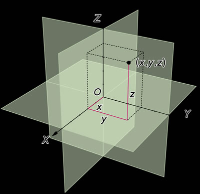 |
| The X, Y, and Z Cartesian coordinate system. (Graphic courtesy of Jorge Stolfi, via Wiki) |
Map datums are mathematical models used to describe the approximate shape of the Earth's surface relative to fixed reference points (or starting points) over a particular region of the Earth.
Known and constant, these reference datums serve as spatial foundations, marrying or tying flat, two-dimensional maps and their coordinate systems to the real world, the curved, three-dimensional Earth.
In the world of geodesy, there are two types of datums: horizontal control datums and vertical control datums.
Horizontal control datums, the focus of this article, permit locations on the Earth's relatively flat surface to be determined by way of their X, or abscissa, and Y, or ordinate, coordinates on a two-dimensional model.
Vertical control datums permit locations on the Earth's surface to be further determined by the addition of a third dimension, their Z, or applicate, coordinate.
Considered together, both geodetic datums can be viewed as an example of an X, Y, and Z-axes common to the Cartesian coordinate system.
Developed in 1637 by René Descartes, the Cartesian coordinate system's name is derived from Descartes' Latin name: Renatus Cartesius.
Rene Descartes 1596-1650. (Photo courtesy of Louvre Museum, Paris, France) Rene Descartes. Rene Descartes (1596-1650) was a celebrated French philosopher, mathematician, and scientist. Known as the father of modern, rationalistic philosophy, Descartes philosophy came to be called Cartesianism.
His accomplishments included inventing coordinate or analytic geometry through the merging of algebra and geometry. An opponent of Scholastic Aristotelianism, Descartes devoted himself to explaining man and the universe through the application of mathematics, logical reasoning, and experimentation.
He became famous for the Latin axiom, cogito, ergo sum, which translated to "I think, therefore I am."
Descartes works included Discourse on the Method for Rightly Conducting Ones Reason, and Searching for Truth in the Sciences (1637; his most famous work), which became known as the Discourse on Method; Meditations on First Philosophy (1641; his principal philosophical work); and Principles of Philosophy (1644).

Top
Spheroids, geoids, & ellipsoids
Contrary to common belief, the Earth is not a smooth, perfectly-round sphere (or spheroid)—it's actually a rather lumpy, irregular geoid.
The Earth's non-perfect, elliptical (or oval) shape is due to slight oblateness (flattening) at both poles, where the circumference is about 40,075 kilometers, and slight bulging at the equator, where the circumference is about 40,008 kilometers.
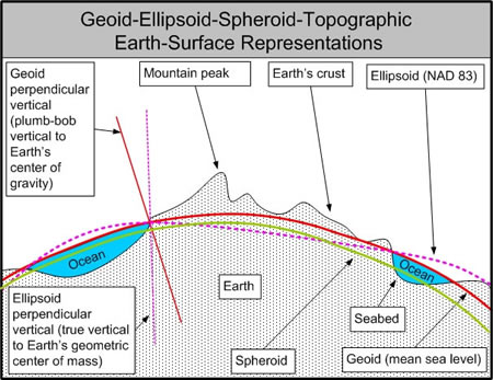 |
| Four cartographic representations of the Earth's surface: the non-datum-related topographic outline (Earth's actual crust); simple spheroid (geometric model); theoretical ellipsoid (geometric model) developed by geodesists; and geoid (physical model) constructed with satellite-based gravitational measurements. (Graphic by Michael A. Neiger) |
The elevation of the Earth's lumpy, irregular surface varies between two extremes: about 8,850 meters above sea level at the peak of Mount Everest, and about 10,920 meters below sea level at the seabed of the western Pacific's Mariana Trench.
While such irregularities do not really effect the utility of small-scale maps and atlases, the Earth's oblate shape and the crust's irregular nature are significant enough that navigators, surveyors, and cartographers striving for accuracy with large-scale maps must take it into account.
Geodesist eventually concluded that earth-centered ellipsoids offered more accurate representations of the Earth's surface as compared to gravity-based, sea-level geoids. much less simple, symmetrical spheroids.
Before the space age and the advent of global satellite mapping technology made triangulation with theodolites, steel tapes, and towers obsolete, mapmakers around the world developed their own local or regional map datums.
Once a master point of origin was established for a local datum, geodetic control points were precisely situated in relationship to it. Arrayed out from these control points were benchmarks and survey markers, particularly blazed trees, concrete pillars, steel pipes, railroad rails, and circular bronze plates fixed in either rock or concrete.
Top
The evolution of
local map datums in the United States
Top
New England Datum of 1879
 |
| Alexander Ross Clarke 1828-1914. (1861 photo courtesy of Southampton Archives in Hampshire, United Kingdom) |
The New England Datum of 1879, part of the Eastern Oblique Arc—a triangulation network surveyed for the eastern and northeastern portions of the United States—became the first official datum of the United States when it was developed in 1879 by the US Coast and Geodetic Survey.
Based on the non-geocentric Clarke ellipsoid of 1866, the datum's point of origin was the Principio Triangulation Station at Principio Furnace, Maryland, which is situated along upper Chesapeake Bay in Cecil County.
Alexander Ross Clarke. Alexander Ross Clarke (1828-1914) was the British geodesist known particularly for his reference ellipsoids—mathematical representations of the geoid shape. His 1866 mathematical model of the Earth's actual shape, accommodating both polar flattening and equatorial bulging, was widely accepted, particularly in the United States, and remained in use until the 1980s.
The father of 13 and a member of the Royal Society, he served in British Army with the Royal Engineers in 1847, and in the Ordnance Survey from 1850 to 1881. His 1880 book Geodesy became a standard text on the subject.
Top
United States Standard Datum of 1901
 |
| The Meade's Ranch Station. (Courtesy of the US National Geodetic Survey) |
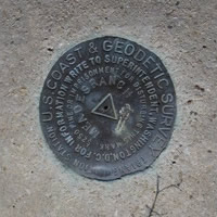 |
| The Meade's Ranch Station bronze monument. (Courtesy of the US National Geodetic Survey) |
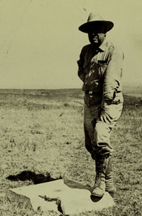 |
| Triangulation station at Meade's Ranch circa 1940 (Photo courtesy of NOAA National Geodetic Survey) |
With the completion of the second great arc of triangulation—the Transcontinental Arc of Triangulation along the 39th parallel of latitude—in 1899, the US Coast and Geodetic Survey renamed the New England Datum of 1879 the United States Standard Datum in 1901.
Based on the Clarke ellipsoid of 1866, the datum's point of origin was the Meade's Ranch Triangulation Station, which was designated as the geodetic center of the United States. This Earth-surface-based datum served as the starting point for all of the country's survey and map work.
Meades Ranch Triangulation Station. In 1891, the Meades Ranch Triangulation Station was established in Osborne County, Kansas as part of the Transcontinental Arc of Triangulation, an unprecedented effort to tie the nation's geodetic networks together.
This 4,224-kilometer-long survey between the Atlantic and Pacific coasts generally followed the great circle known as the 39th parallel of latitude.
The Meade's Ranch station takes its name from the person who first homesteaded the site, William H. Meade. In 1936, the pastureland surrounding the monument became known as Robinson's Farm when it was purchased by Frank Robinson.
The land is now owned by his grandson, Kyle Brant. The ranch is located in the southwest quarter of Section 34 in Township 9 south, Range 11 west, approximately 12 miles north of Lucas, Kansas and 16 miles southwest of Tipton, Kansas.
The government survey crew that established this station on the low, grassy, east-west-running ridge reportedly installed a marble post inscribed with the letters "U.S.C.S." A cross was chiseled into the top of the post to mark the station's exact point of origin. An ash-filled bottle was been buried beneath the post, about three feet below the surface.
While the Meade's Ranch Station served as the geodetic center of the country, the geographic center of the 48 contiguous states is Lebanon, Kansas, which is situated some 42 miles to the north, in Smith County. With Hawaii and Alaska included, the geographic center shifts to an area in South Dakota.
In 1922, the Meade's Ranch Station marble monument was replaced by a concrete one bearing a bronze disk inscribed with " Meades Ranch 1891."
In 1948, the deteriorated, 1922, concrete monument was upgraded to a 24-inch, round, concrete monument. The original bronze marker was reset in the new, mushroom-shaped monument.
In 1973, the historic Meade's Ranch Triangulation Station was added to the National Register of Historic Places.
That same year, Frank L. Culley, Senior Mathematician with the United States Coast and Geodetic Survey described this unpretentious monument as:
A bronze disk, 3.6 inches in diameter, set in the top of a block of concrete 24 inches square at the top, 36 inches square at the base, and 3 feet high, set in the ground so that its top surface is 6 inches above the ground.
Today, the open grassland site of the Meade's Ranch monument remains privately owned.
Up until the adoption of the North American Datum of 1983 (NAD 83) in 1989, surveys of a sixth of the Earth's surface were tied to this survey monument, which was known as a "Primary Station."
Top
North American Datum of 1913 (NAD 13)
 With
the extension of the 98th Meridian Arc of Triangulation to the control
networks of Mexico and Canada, and the assention of both countries, the
US Standard Datum of 1901 officially became the North American Datum in
1913.
With
the extension of the 98th Meridian Arc of Triangulation to the control
networks of Mexico and Canada, and the assention of both countries, the
US Standard Datum of 1901 officially became the North American Datum in
1913.
Based on the Clarke ellipsoid of 1866, the datum's point of origin was the Meade's Ranch Triangulation Station.
Top
North American Datum of 1927 (NAD 27)
Continent-wide corrective readjustments to some 25,000 geodetic control points across North America in the later half of the 1920s resulted in the establishment of the North American Datum of 1927.
Based on the Clarke ellipsoid of 1866, the datum's point of origin was the Meade's Ranch Triangulation Station.
Top
North American Datum of 1983 (NAD 83)
Qualitative improvements in the science of geodesy—and the need for a single, truly-geocentric datum tied to the center of Earth's mass (as opposed to a fixed point on it's surface) that would have worldwide as opposed to regional coverage, and that would accommodate satellite-derived coordinates—led to the development of the North American Datum of 1983. Based on the global, geocentric ellipsoid known as the Geodetic Reference System of 1980 (GRS 80), the datum's point of origin was the center of the Earth's mass, the same point around which satellites orbit.
Between its formal adoption in 1989 and 2005, the North American Datum of 1983 and its 250,000 geodetic control points underwent a series of corrective adjustments—using the High-Accuracy Reference Network (HORN) and a system of Continuously Operating Reference Stations (CORS)—a multinational (US, Canada, Denmark, and Latin America) effort that greatly improved its accuracy.
The Earth-centered North American Datum of 1983 is currently the official horizontal datum for the North American Continent, including the United States, Canada, Mexico, and Central America.
Top
The
evolution of global map datums
 In
the decades after the close of World War II, the patchwork of hundreds
of local, regional, national, and continental map datums could not accommodate
the intercontinental or global—much less interplanetary or interstellar—scale
towards which civilian, commercial, scientific, and military initiatives
were headed.
In
the decades after the close of World War II, the patchwork of hundreds
of local, regional, national, and continental map datums could not accommodate
the intercontinental or global—much less interplanetary or interstellar—scale
towards which civilian, commercial, scientific, and military initiatives
were headed.
To meet the demand for a highly-accurate, internationally-accepted, unified geodetic system with a worldwide datum, the US Department of Defense began began working on what would become known as the World Geodetic System (WGS).
Top
World Geodetic System
of 1960 (WGS 60)
In 1960, the US Department of Defense consolidated the two world systems developed by the US Army and US Air Force—both which accurately accommodated three principle international datums: the North American Datum of 1927 (NAD 27), Tokyo Datum (TD), and European Datum (ED)—to create the World Geodetic System of 1960 (WGS 60).
Based on the WGS 60 ellipsoid, the datum's point of origin was the center of the Earth.
Top
World Geodetic System of
1966 (WGS 66)
In 1966, advances in the science of geodesy and surveying allowed the US Department of Defense to develop the World Geodetic System of 1966 (WGS 66).
Based on the WGS 66 ellipsoid, the datum's point of origin was the center of the Earth.
Top
World Geodetic System of
1970 (WGS 70)
In 1970, continued advances in the science of geodesy and surveying allowed the US Department of Defense to develop the World Geodetic System of 1970 (WGS 70).
Based on the WGS 70 ellipsoid, the datum's point of origin was the center of the Earth.
Top
World Geodetic System of
1972 (WGS 72)
In 1972, continued advances in the science of geodesy and surveying allowed the US Department of Defense to develop the World Geodetic System of 1972 (WGS 72).
Based on the WGS 72 ellipsoid, the datum's point of origin was the center of the Earth.
Top
World Geodetic System of
1984 (WGS 84)
In 1984, continued advances in the science of geodesy and surveying—particularly precise satellite data altimetry and sensitive Doppler satellite observations—allowed the World Geodetic Society to develop the World Geodetic System of 1984 (WGS 84) as the new, international datum. Satellite-driven accuracy gave this datum worldwide scope, meaning a single coordinate system could uniformly cover the entire world.
 Like
the North American Datum of 1983 (NAD 83), WGS 84 was based on the global
ellipsoid known as the Geodetic Reference System of 1980 (GRS 80). The
datum's point of origin was the center of the Earth.
Like
the North American Datum of 1983 (NAD 83), WGS 84 was based on the global
ellipsoid known as the Geodetic Reference System of 1980 (GRS 80). The
datum's point of origin was the center of the Earth.
WGS 84 currently serves as the official horizontal datum for the US Department of Defense as well as the world. Used by Global Positioning System (GPS) satellites, WGS 84 is the default datum on most recreational, commercial, and military GPS units.
Top
Maps
and map datums
Most maps and charts suitable for technical navigational purposes will specify the reference datum used to produce the map, either in the legend or a separate annotation along the map's margin or collar.
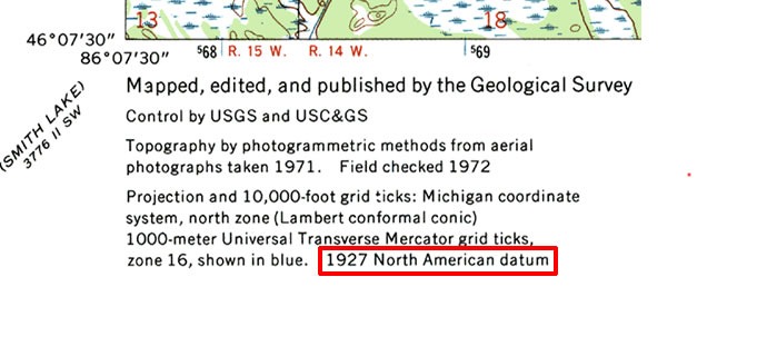 |
| Map datum info in the marginal legend of a 1972-edition, 1:24,000, USGS quadrangle. |
 |
| Map datum info in the marginal legend of a 1985-edition, 1:24,000, USGS quadrangle. |
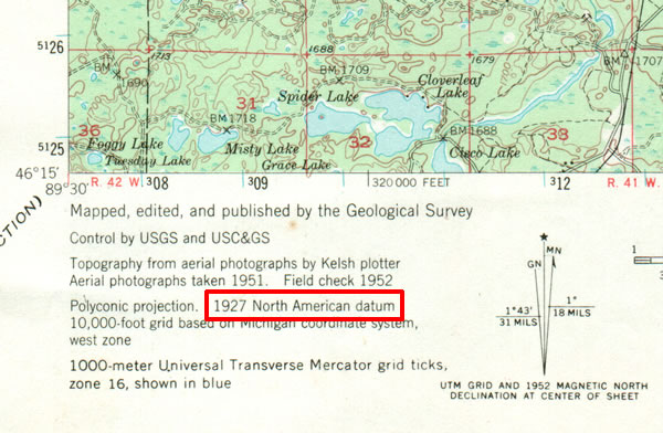 |
| Map datum info in the marginal legend of a 1952-edition, 1:62,500, USGS quadrangle. |
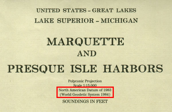 |
| Map datum info in the marginal legend of a 1994-edition, 1:15,000, NOAA quadrangle. |
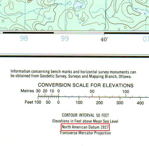 |
| Map datum info in the marginal legend of a 1986-edition, 1:50,000, Canadian Map Office quadrangle. |
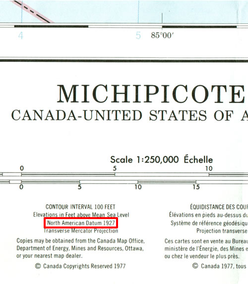 |
| Map datum info in the marginal legend of a 1977-edition, 1:250,000, Canadian Map Office quadrangle. |
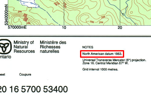 |
| Map datum info in the marginal legend of a 2002-edition, 1:20,000, Ontario Ministry of Natural Resources quadrangle. |
Top
GPS units and map datums
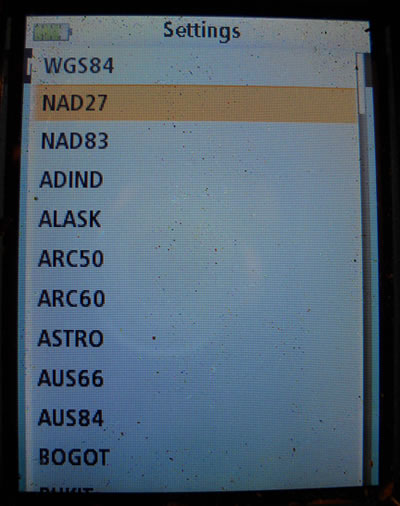
All global positioning system (GPS) units have a menu in the system's setup that allows users to specify the particular datum they want to use. Click here to view Garmin's list of available datums.
 |
| Map datum selection choices in Magellan's Triton 1500 global positioning system (GPS) unit via MENU-VIEW-SETTINGS-NAVIGATION-MAP DATUM screens. |
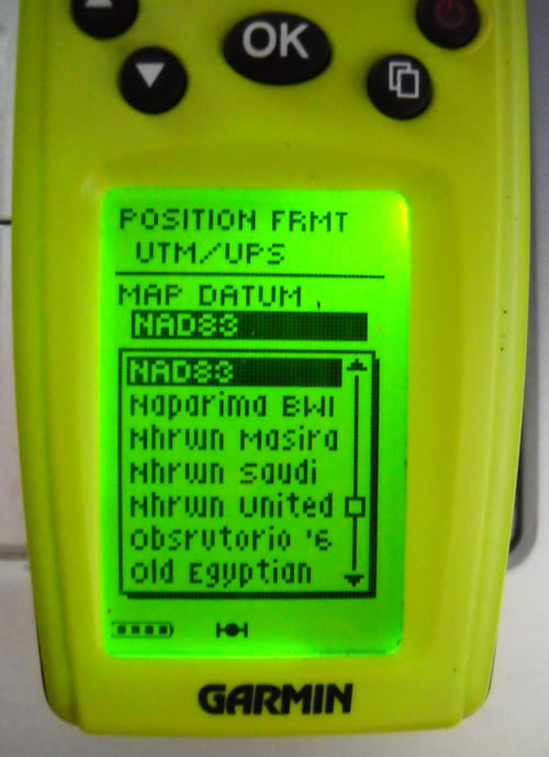 |
| Map datum selection choices in Garmin's Geko 201 global positioning system (GPS) unit via MENU-SETUP-UNITS-MAP DATUM screens. |
Top
Digital
mapping software and map datums
All digital mapping software packages allow users to select the map datum to be used with the mapping program.
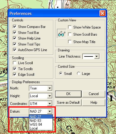 |
| Map datum selection choices in MapTech's Terrain Navigator mapping software preference's menu. |
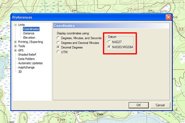 |
| Map datum selection choices in National Geographic's TOPO! mapping software preference's menu. |
Top
Converting coordinates between map datums
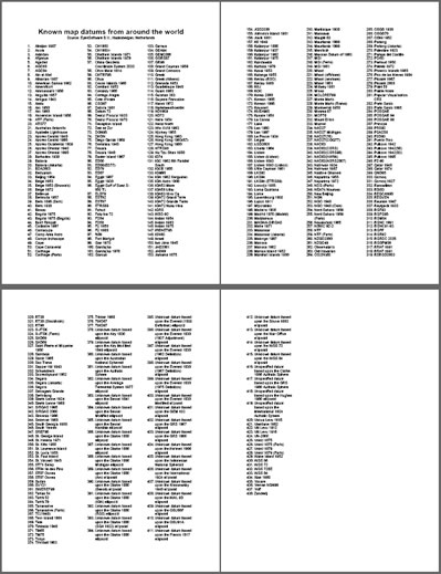 |
| Hundreds of local, regional, national, and continental map datums exist worldwide. (List adapted from material compiled courtesy of Haaksbergen, Netherlands' Eye4Software B.V.) |
Careful datum transformation is essential when migrating coordinates from one datum to another to avoid data degradation.
Eyes4Software BV of Haaksbergen, Netherlands has cataloged no less than 438 datums worldwide.
While software utilities are available for data transformation, most GPS units and digital mapping programs will automatically recalculate coordinate data strings by simply changing the unit's or software's datum.
To convert coordinates already in a GPS unit or mapping software program, simply select the desired map datum in the system's setup menu.
Once the new datum is selected, the coordinates with automatically be transformed from the old datum to the new datum.
To use a GPS unit or mapping software program to convert coordinates received from another source, the unit's or program's map datum setup must be set to that which the data was calcutated with before inputting the coordinates themselves.
Once the correct datum has been selected and the coordinates entered, simply change the map datum setup selection as desired and the coordinates will be automatically recalculated to the new datum.
Coordinates from quadrangles, GPS units, and digital mapping software programs must be married to the same spatial reference system for cross-platform cartographic accuracy.
When working with hardcopy maps, make sure your GPS unit's map datum coincides with the map datum used by the mapmaker.
Top
Map datum
errors
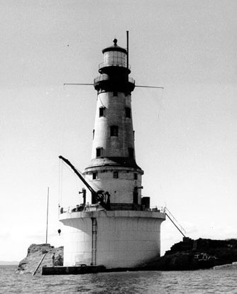 |
| The Rock of Ages Lighthouse off the west end of Isle Royale in the northwestern corner of Lake Superior. (Photo courtesy of the United States Coast Guard) |
 |
|
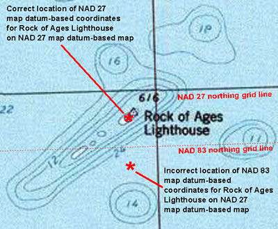
A 207-meter northing error is the result of using NAD 83 map datum-based coordinates for the Rock of Ages Lighthouse on a NAD-27 map datum-based quadrangle. (Cartography by Michael Neiger) |
With hundreds of local, regional, national, and continental map datums in existence across the globe, it's essential that land navigators and cartographers know what particular map datum is associated with every set of map coordinates, irrespective of whether they are Latitude/Longitude (Lat/Lon) coordinates or Universal Transverse Mercator (UTM) coordinates obtained from quadrangles, global positioning system (GPS) units, or digital mapping software programs.
Map datum mismatches can result in significant errors in accuracy, up to 200 or 300 meters in the conterminous United States, and perhaps up to 1,600 meters in some regions of the world.
And datum shift is not constant—significant, systematic distortions occur over large areas.
The Rock of Ages Lighthouse just off the western tip of Lake Superior's Isle Royale offers a good example of the consequences of failing to account for different map datums.
When the lighthouse's NAD 83 coordinates are plotted on the USGS 1:24,000 Feldtmann Lake OEW, Michigan quadrangle—which is married to the NAD 27 map datum—the error is substantial, especially if one were navigating a storm or fog.
While the easting coordinate error is nominal, only 2 meters, the northing coordinate error is more significant: 207 meters.
Top
|
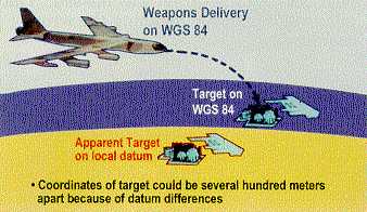
Know your map datums! Correct map-datum selection is essential for team-level operational accuracy as well as joint interoperability among different agencies If you're a ground pounder coordinating with nautical and/or aerial assets—irrespective of whether you're using the Lat/Lon or UTM coordinate system—keep in mind most current nautical and aeronautical charts are based on the NAD 83 (or WGS 84) map datum, not the NAD 27 datum common to most current USGS quadrangles. Map-datum selection or conversion errors are blamed for numerous friendly-fire accidents—some of the deadliest— in U.S. conflicts such as the 1990-1991 Persian Gulf War (Desert Storm), the 2001-current War in Afghanistan (Operation Enduring Freedom), the 2003-current Iraq War (Operation Iraqi Freedom).
(Imagery courtesy of the US National Geospatial-Intelligence Agency) |
Reminders
- Current maps for the North American Continent are
supported by three principal map datums: NAD 27, NAD 83, and WGS 84.
- The difference between the Earth-centered, NAD 83
and WGS 84 datums is nominal, so they can be considered equivalent and
interchangeable.for general land navigation purposes,
- Most GPS units boot up with a default map datum of
WGS 84.
- Some GPS receivers subdivide the NAD 27 datum into
regional datums, with the continental United States being designated
by NAD 27 CONUS (CONtinentalUS) and Canada
by NAD 27 CA (CAnada).
- While most current nautical and aerial charts are
supported by the NAD 83 and WGS 84 map datums—which for all practical
purposes are the same—almost all 7.5-minute United States Geological
Survey (USGS) quadrangles in print today are only supported by the NAD
27 map datum. Look for newer edition 7.5-minute USGS quads to carry
the more accurate NAD 83 map datum.
- The most common mistake made with regard to map datums
by wilderness trippers is moving GPS coordinates between USGS quadrangles
and GPS units without setting the GPS unit's map datum to same datum
as the quad: NAD 27.
- While a single map may have several different grid
coordinate systems (Lat/Lon, UTM, SPC [State Plane Coordinate], etc.),
it can only have one datum.
- Two maps with different map datums may not line up
exactly along their adjacent neat lines (boundaries) as their neat lines
and corner points may be slightly different, depending on the amount
of datum shift.
- Any map accurate enough for navigational purposes—say
one showing the latitude and longitude geographic coordinate system—will
also carry the applicable reference datum.
- Always pay attention to the reference datum associated
with coordinates, maps, GPS units, mapping software programs, etc. The
same datum must be used across all these platforms to avoid significant
accuracy errors.
- Anyone working with map coordinates must take pains to record the applicable map datum as well as the coordinates themselves, whether they're plotted on a large-scale paper map, generated by a global positing unit, or calculated with a digital mapping software program.
Top
References
 |
|
Map Use: Reading,
Analysis, and Interpretation,
fifth edition, by Phillip C. Muehrcke and Juliana O. Muehrcke (Madison,
Wisconsin: JP Publications, 2005)
|
Analytical and Computer Cartography, by Keith C. Clarke (Englewood Cliffs, New Jersey: Prentice Hall, 1990)
Applied Cartography: Source Materials for Mapmaking, by Thomas D. Rabenhorst and Paul D. McDermott (Columbus Ohio: Merrill Publishing Co., 1989)
ArcGIS 9: Understanding Map Projections, by Melita Kennedy (Redlands, California: Environmental Systems Research Institute [ESRI], 2004)
Basic GIS Coordinates, by Jan Van Sickle (Boca Raton, Florida: CRC Press LLC, 2004)
Basic Land Navigation (NFES 2865), by Mary Bogens, Michael Durfee, Lee Gardner, and Richard Streeper (Boise, Idaho: National Interagency Fire Center, Fire Training, 2007)
Coastlines: How Mapmakers Frame the World and Chart Environmental Change, by Mark Monmonier (Chicago, Illinois: University of Chicago Press, 2008)
Compass and Map Navigator: The Complete Guide to Staying Found, revised edition by Michael Hodgson (Guilford, Connecticut: The Globe Pequot Press, 2000)
The Complete Guide to Orienteering in North America: A Comprehensive Manual for the Outdoorsman, by Berndt Berglund (Toronto, Canada: Pagurian Press, 1979)
The Complete Idiot's Guide to Geocaching, by Jack W. Peter (Indianapolis, Indiana: Alpha Books, 2004)
A Comprehensive Guide to Land Navigation with GPS, third edition, by Noel J. Hotchkiss (Herndon, Virginia: Alexis Publishing, 1999)
Concepts and Techniques of Geographic Information Systems, by C. L. Lo and Albert K. W. Yeung (Upper Saddle River, New Jersey: Prentice Hall, 2002
Datums, Ellipsoids, Grids, and Grid Reference Systems (Defense Mapping Agency Technical Manual 8358.1), by John W. Hager, Larry L. Fry, Sandra S. Jacks, and David R. Hill (Fairfax, Virginian: Defense Mapping Agency Combat Support Center, 1990)
The Essential Wilderness Navigator: How to Find Your Way in the Great Outdoors, by David Seidman (Camden, Maine: Ragged Mountain Press, 1995)
Flattening the Earth: Two Thousand Years of Map Projections, by John P. Snyder (Chicago, Illinois: University of Chicago Press, 1993)
Fundamentals of Geographic Information Systems, fourth edition, by Michael N. Demers (Hoboken New Jersey: John Wiley and Sons, Inc., 2009)
Geodesy for the Layman (Defense Mapping Agency Technical Report 80-003), (St. Louis AFS, Missouri: Defense Mapping Agency Aerospace Center, 1983)
Geographic Information Systems Demystified, by Stephen R. Galati (Boston, Massachusetts: Artech House, 2006)
Geographic Information Systems for Geoscientists: Modeling with GIs, by Graeme F. Bonham-Carter (Tarrytown, New York: Elsevier Science Inc., 1994)
Getting Started With Geographic Information Systems, fourth edition, by Keith C. Clarke (Upper Saddle River, New Jersey: Prentice Hall, 2003)
GIs Data Conversion: Strategies, Techniques, and Management, Pat Hohl (Santa Fe, New Mexico, 1998)
GIs for Dummies, by Michael N. DeMers (Hoboken, New Jersey: Wiley Publishing, Inc., 2009)
GIs: The Geographic Language of Our Age, by Knut Grinderud, Haakon Rasmussen, Steinar Nilsen, Arvid Lillethun, Atle Holten, and Øystein Sanderud (Trondheim, Norway: Tapir Academic Press, 2009)
GPS for Dummies, by Joel McNamara (Indianapolis, Indiana: Wiley Publishing Inc., 2004)
The GPS Handbook: A Guide for the Outdoors, by Robert I. Egbert and Joseph E. King (Short Hills, New Jersey: Burford Books, 2003)
GPS Made Easy: Using Global Positioning Systems in the Outdoors, by Lawrence Letham (Seattle, Washington: The Mountaineers, 1998)
A GPS User Manual: Working With Garmin Receivers, by Dale DePriest (N.P., NP: 1st Books Library, 2003)
Integrated Geospatial Technologies: A Guide to GPS, GIs, and Data Logging, by Jeff Thurston, Thomas K. Poiker, and J. Patrick Moore (Hoboken, New Jersey: John Wiley and Sons, Inc., 2003
Introduction to Geographic Information Systems, fourth edition, by Kang-tsung Chang (New York, New York: McGraw Hill, 2008)
Land Navigation Handbook: The Sierra Club Guide to Map, Compass, and GPS, 2nd edition, by W. S. Kals, revised by Clyde Soles (San Francisco, California: Sierra Club Books, 2005)
The Language of Maps, by Philip J. Gersmehl (Indiana, Pennsylvania: National Council for Geographic Education, University of Pennsylvania, 1991)
Map Projections Used by the US Geological Survey, 2nd edition (Geological Survey Bulletin 1532), by John P. Snyder (Washington, D.C.: United States Government Printing Office, 1982)
Mapping, by David Greenhood, revised by Gerald L. Alexander (Chicago, Illinois: University of Chicago Press, 1964)
Maps and Compasses, second edition, by Percy W. Blandford (Blue Ridge Summit, Pennsylvania: Tab Books, 1992)
Mapping Hacks—Tips & Tools for Electronic Cartography, by Schuyler Erle, Rich Gibson, and Jo Walsh (Sebastopol, California: O'Reilly Media, Inc., 2005)
Map Reading and Land Navigation (FM 21-26), (Washington, DC: Department of the Army, 1993)
Map Reading and Land Navigation (FM 3-25.26), (Washington, DC: Department of the Army, 2001)
Map Use: Reading, Analysis, and Interpretation, fifth edition, by Phillip C. Muehrcke and Juliana O. Muehrcke (Madison, Wisconsin: JP Publications, 2005)
Map Use and Analysis, third edition, by John Campbell (Boston, Massachusetts: WCB/McGraw-Hill, 1998)
Measurements from Maps: Principle & Methods of Cartography, by D.H. Maling (Oxford England: Perganon Press, 1989)
Sniper Training and Employment (TC 23-14), (Washington, DC: Department of the Army, 1969)
Thinking About GIs: Geographic Information System Planning for Managers, by Roger Tomlinson (Redlands, California: ESRI Press, 2003)
The Universal Grids: Universal Transverse Mercator (UTM) and Universal Polar Stereographic (UPS) (Defense Mapping Agency Technical Manual 8358.2), by John W. Hager, James F. Behensky, and Brad W. Drew (Fairfax, Virginian: Defense Mapping Agency Combat Support Center, 1989)
The Universal Transverse Mercator (UTM) Grid (Fact Sheet 077-01), by the US Geological Survey (Reston, Virginia: US Geological Survey, 2001
Using GPS: GPS Simplified for Outdoor Adventures, by Bruce Grubbs (Falcon Publishing, Inc.: Helena, Montana, 1999)
Using the UTM Grid to Record Historic Sites, by Wilford P. Cole, US Department of the Interior (Washington, DC: US Government Printing Office, 1980)
UTM: Using your GPS with the Universal Transverse Mercator Coordinate System, third edition, by John Carnes (Woodside, California: MapTools, 2007)
Wilderness Navigation: Finding Your Way Using Map, Compass, Altimeter, and GPS, by Bob Burns and Mike Burns (Seattle, Washington: The Mountaineers, 1999)
Return to top of page :: Return to home page
In God's wilderness
lies the hope of the world,
the great, fresh, unblighted,
unredeemed wilderness.
—
John Muir, 1838-1914
Alaska Wilderness, 1890
If
you've been able to read this Web page...
thank a Teacher;
If you've been able to read this Web page in English...
thank a Veteran.
—Author
unknown
•
Copyright notice •
Content Copyright © 1984 —
2012-07-04
by Michael A. Neiger
• All rights reserved •
No part of this Web page or this Web site protected by copyright law may be reproduced, transmitted, or used in any form—including graphic, electronic, Web, mechanical or other form—or by any means—including photocopying, recording, taping, Internet distribution, information storage retrieval system, or by other means—for any purpose, except by a reviewer, who may quote brief passages, without the prior, express, written permission of the author.
Comments?
Suggestions?
Dead links? Inaccurate info?
Contact the WebMaster, Michael A. Neiger, at mneiger@hotmail.com
Web site URL: www.MibSAR.com
Return to top of page :: Return to home page
You're here: MiBSAR's home page :: SAR operations land navigation resource index page :: Map datum page