
You're here: MiBSAR
:: SAR Ops ::Joe
Clewley SAR Ops Page :: SAR land nav beta
You're here: Backpacker
Magazine's Midwest Forum :: Joe
Clewley Discussion Thread :: Joe Clewley
SAR Ops Page :: SAR land nav beta
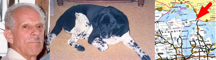
A Michigan
Backcountry Search and Rescue Op
for
Joseph Robert Clewley
Missing since July 13, 2008
by
Michael A. Neiger (a.k.a. LandNavMan)
Senior SAR Team Leader
Michigan Backcountry Search and Rescue
Marquette :: Michigan
SAR Team land nav beta
Page contents
•
SAR land nav info
•
SAR digital imagery (new
09-19-08)
•
SAR placename coordinates (new
08-27-08)
North
Country Trail (NCT)
Tahqua
Trail
Tahquamenon
River
Timberlost
Road
I believe
that there is a subtle magnetism in Nature,
which, if we unconsciously yield to it, will direct us aright.
— Henry David Thoreau, "Walking,"
Atlantic Monthly, June 1862
<< Prior page Return to Table of Contents Page Next page >>
Top of page
SAR land nav info
Topographic maps:
- 1:24,000 Timberlost, Michigan
- 1:24,000 Emerson, Michigan
Note no. 1: UTM easting and northing grid lines may need to be drawn on these quads
Note no. 2: If you're printing out your own maps, overlay them with the UTM grid that corresponds to NAD 27 datum
Topo map ordering info and waterproofing info
County maps:
- Chippewa County
County map ordering info
Additional cartographic resources
- 1:100,000 Curley Lewis Road to Grand Marais (Map Mi-09) North Country Trail segment map published in 2003 (Available from the North Country Trail Association at 1-866-445-3628)
- 1:126,720 Hiawatha National Forest Service Map, Michigan 2001
US Forest Service
St. Ignace Ranger District
1798 US Highway 2
St. Ignace, Michigan 49781
1-906-643-7900
GPS setup:
Grid coordinate system:
1000-meter Universal Transverse Mercator (UTM) Grid
UTM grid horizontal map datum:
1927 North American Datum CONtinental U.S. (NAD 27 CONUS)
UTM grid zone:
Zone 16
UTM grid hemisphere:
Northern hemisphere
Unit of measure:
Metric
Battery type:
Use lithium for deep cold and long-range use
Battery setting:
Select type of battery being used for accurate battery-life readings
Owner info:
In the setup menu, keypunch in your name, address, and phone number so if your GPS is lost and found by a willing party, it can be returned to you.
Magnetic declination:
August 2008 Magnetic declination for Lat. 46° 34' 00"N, Lon. 85° 07' 30"W:
06° 44' west
Deviation of UTM easting grid lines from meridian of longitude lines:
Timberlost quad: 01° 19' east
Emerson quad: to 01° 24' eastMagnetic declination of UTM easting grid lines:
Timberlost quad: 8° 03
Emerson quad: 8° 8' westNote: We'll use these magnetic declination figures to correct our field and map azimuth calculations, which will be based on the UTM easting grid lines, not the meridians of longitude lines.
Roamer UTM plotter scales:
1:24,000
Ranger pacing beads:
Metric: Nine 100-meter beads and four 1-kilometer beads
Top of page
SAR digital imagery
Topographic maps:
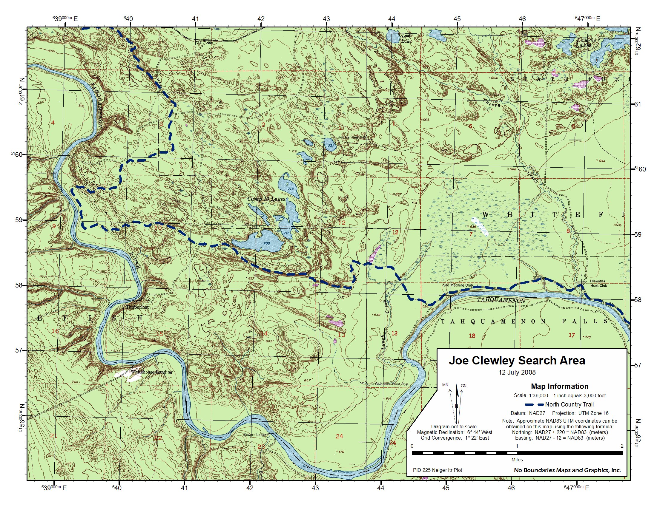
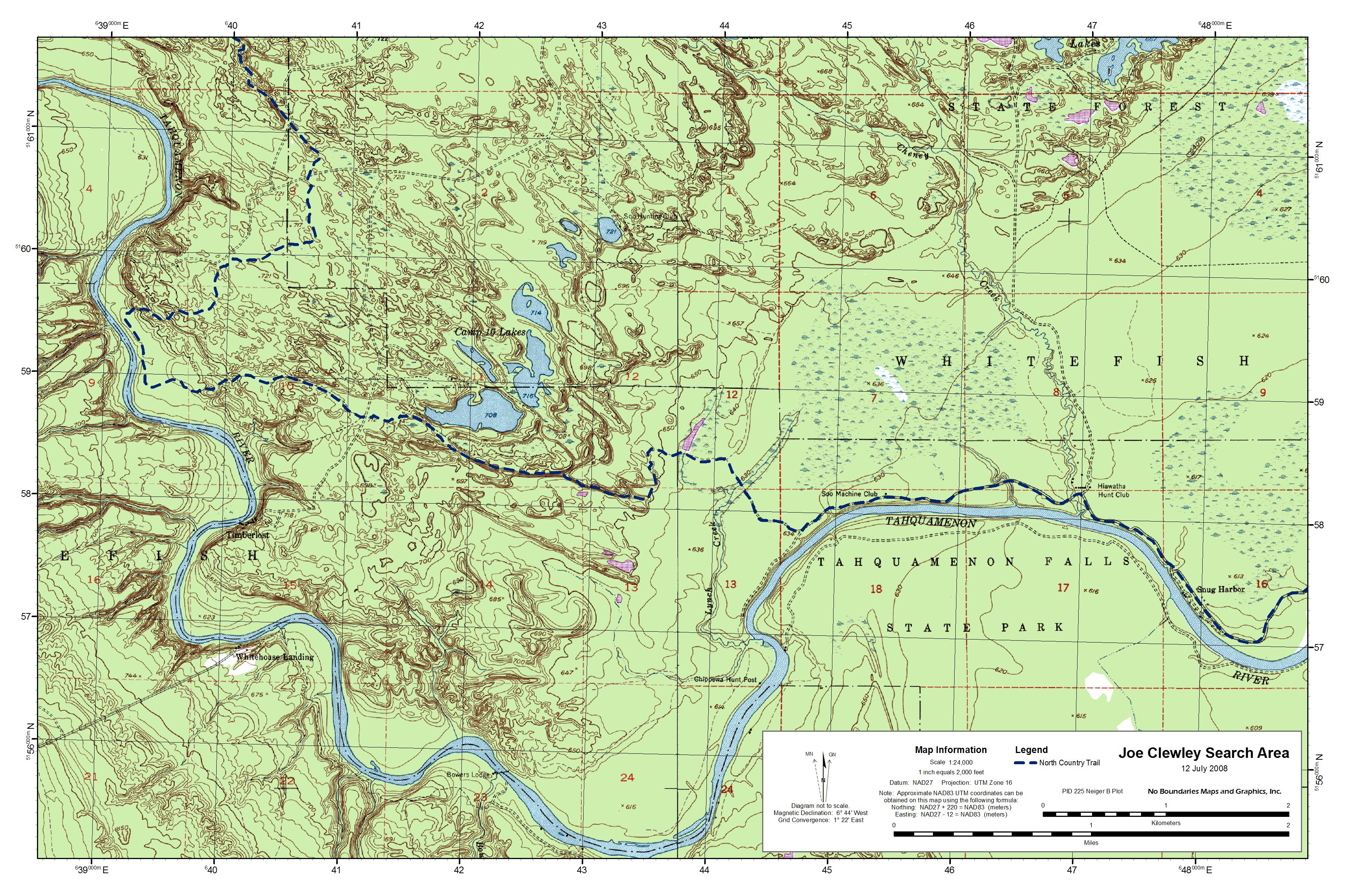
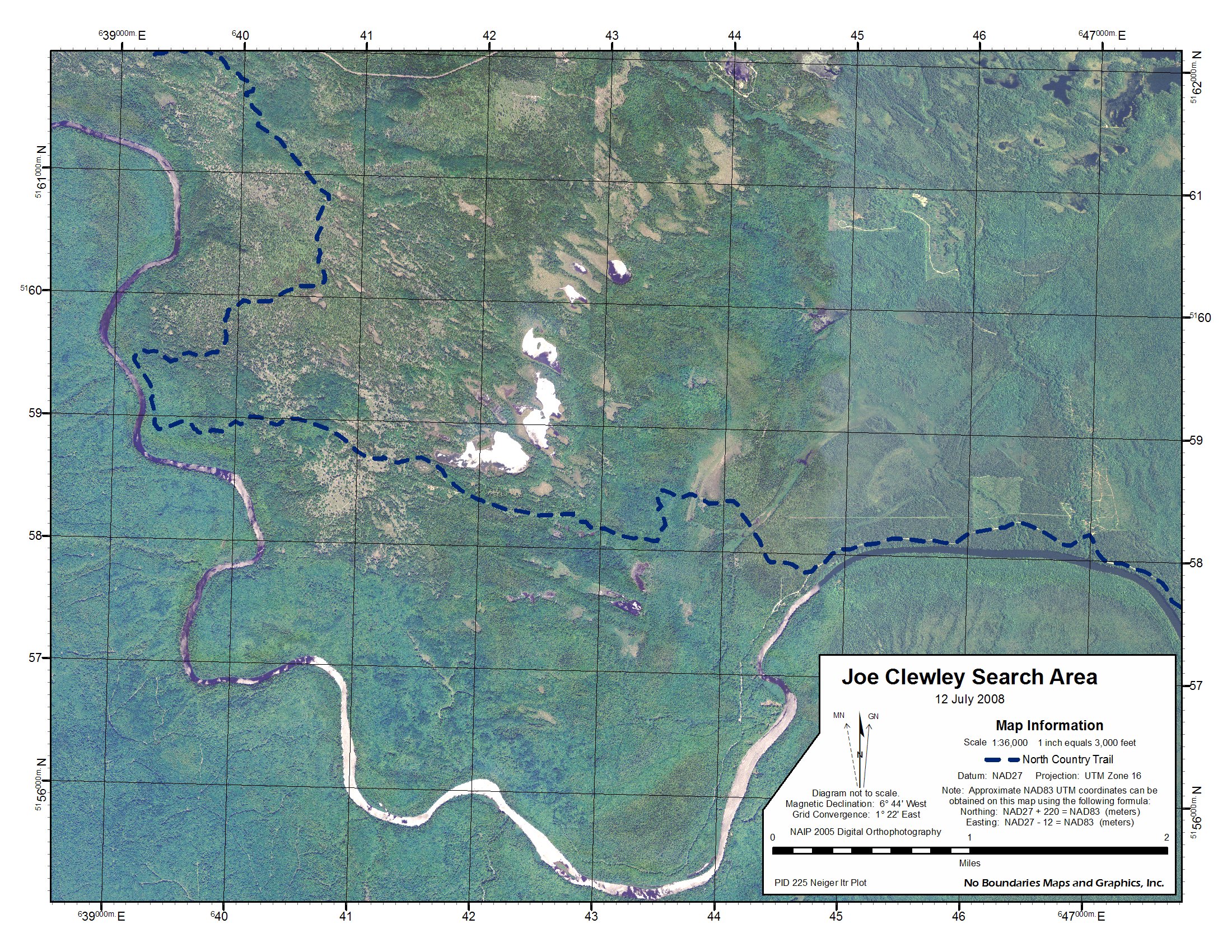
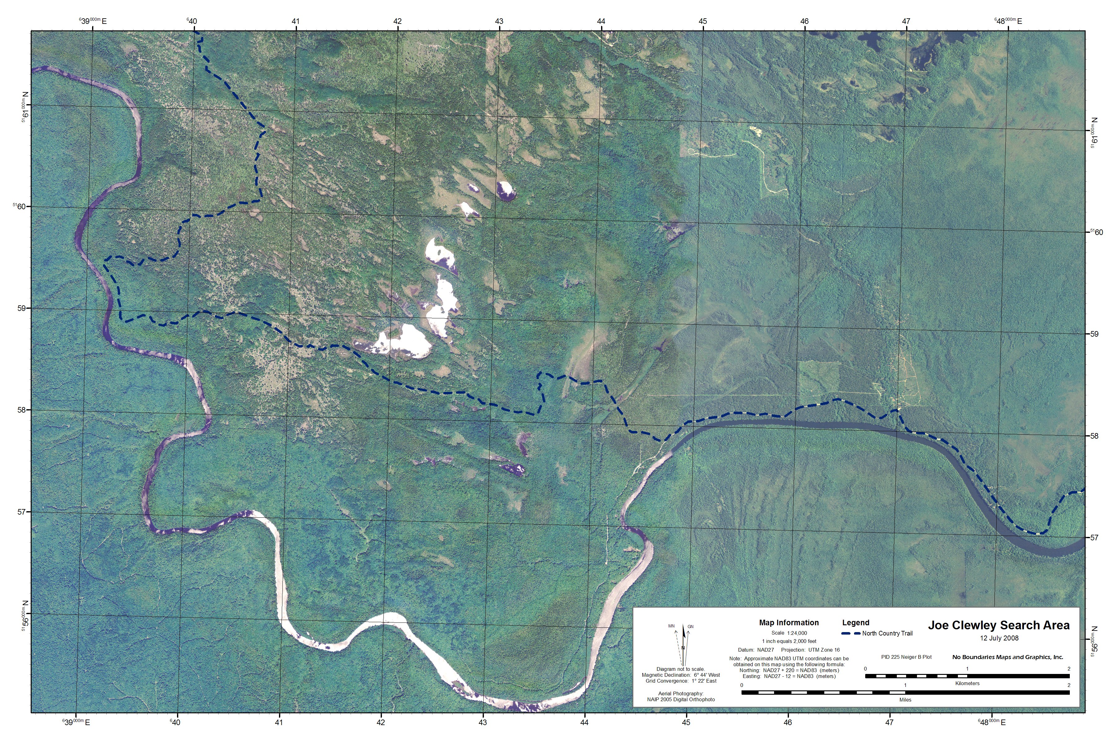
8.5- by 11-inch 1:36,000 USGS topographic image (1.26 MB file size) of search area overlaid with 1,000-meter Universal Transverse Mercator (UTM) grid, 1927 North American Datum, Zone 16. (Source: Custom cartographic work and digital imagery courtesy of Chuck McCready and No Boundaries Maps and Graphics, Inc., Sault Ste. Marie, Michigan, a sponsor of the Michigan Backcountry Search and Rescue.)
Satellite images:
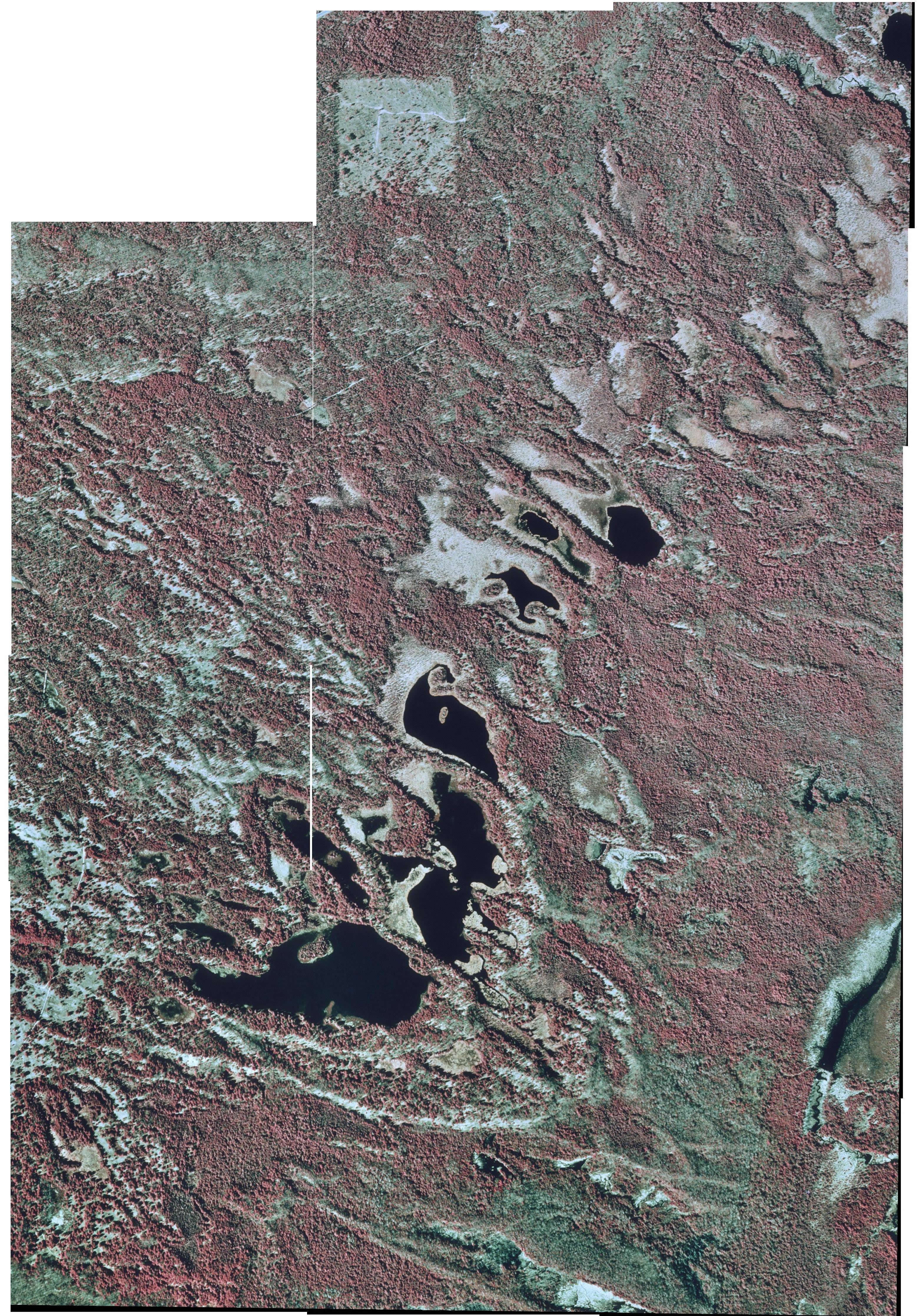
- 29- by 40-inch 1998 aerial image (1.26 MB file size) of Emerson NW-SW portion of search area. (Source: These USGS Digital Orthophoto Quadrangle mosaics--captured in April of 1998--were obtained from the Michigan Department of Natural Resources' Aerial Imagery Archive by Chris Ozminski [NightBlazer] of Frankenmuth, Michigan. Since Chris was forced to painstakingly combine multiple screen saves to create them, they may contain minor alignment imperfections.)
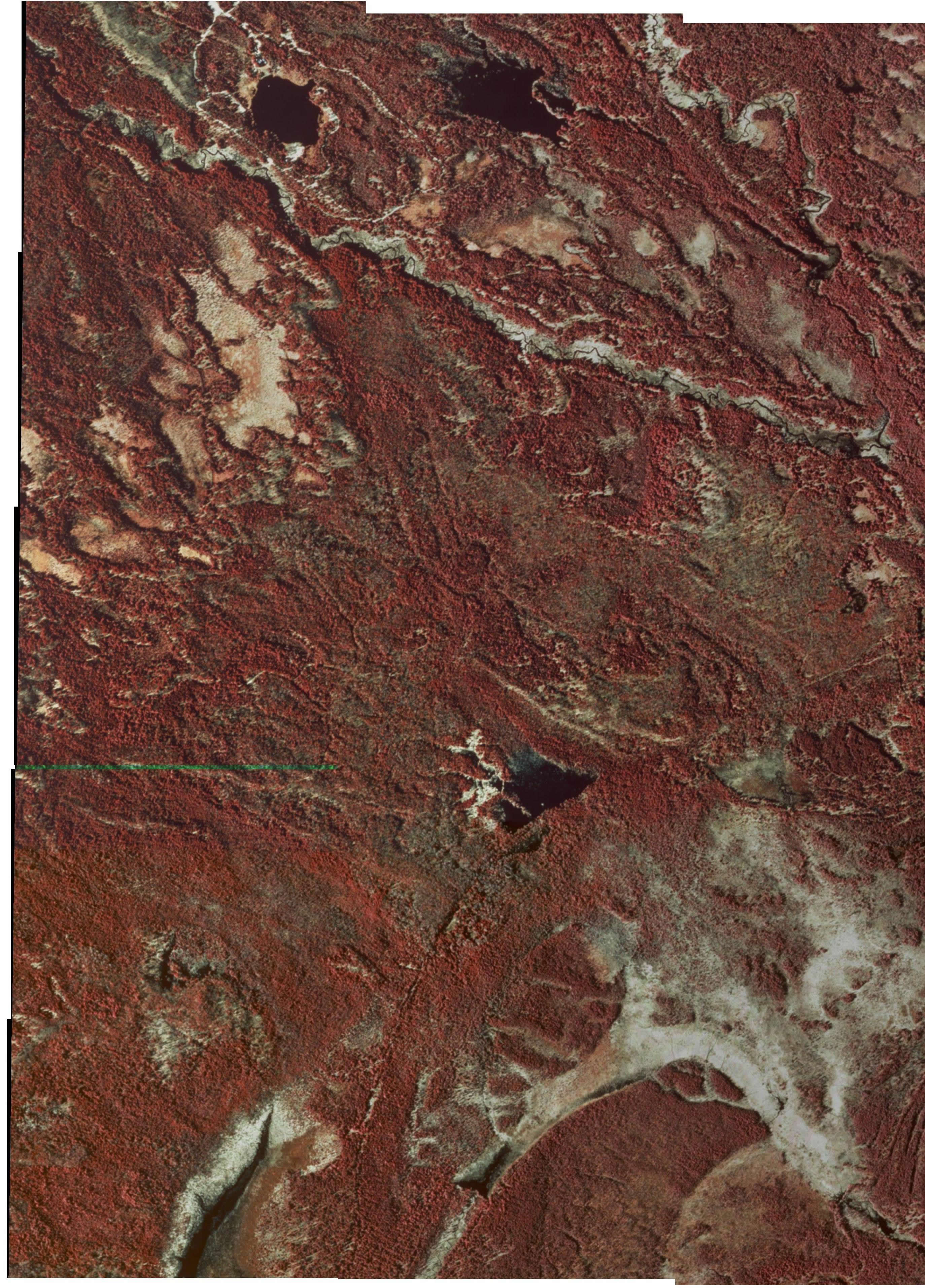
- 33- by 47-inch 1998 aerial image (2.80 MB file size) of Timberlost NE-SE portion of search area. (Source: These USGS Digital Orthophoto Quadrangle mosaics--captured in April of 1998--were obtained from the Michigan Department of Natural Resources' Aerial Imagery Archive by Chris Ozminski [NightBlazer] of Frankenmuth, Michigan. Since Chris was forced to painstakingly combine multiple screen saves to create them, they may contain minor alignment imperfections.)
Look at this vigorous plant that lifts its head from the meadow,
see how its leaves are turned to the north, as true as the magnet; this is the compass-flower,
that the finger of god has planted here in the houseless wild, to direct the traveler's journey.
—Henry W. Longfellow, 1807-1882, Evangeline, 1847
Top
of page
SAR
placename coordinates

Sunset over Lake 708 in the chain of
Camp 10 Lakes.
Photo from SAR Team
Op No. 1 by Michael Neiger
North Country Trail coordinates, east to west
North Country Trail (NCT) Trailhead at Tahqau Trail
UTM coordinates: 0644720mE 5157840mN (Zone 16; Datum NAD 27 CONUS)
Public Land Survey System (PLSS) description: northwest quarter of the northwest quarter of Section 18, Township 48 North, Range 6 West
USGS 1:24,000 quadrangle: Emerson, Michigan, 1951 (Rev. 1975)
Trail miles west of Tahqua Trail: 0.0 miles
Cloverland Electric Co-op Powerline (underground)
UTM coordinates: 0644529mE 5157912mN (Zone 16; Datum NAD 27 CONUS)
Public Land Survey System (PLSS) description: northeast quarter of the northeast quarter of Section 13, Township 48 North, Range 7 West
USGS 1:24,000 quadrangle: Emerson, Michigan, 1951 (Rev. 1975)
Trail miles west of Tahqua Trail: 0.1 miles
Headwaters Pond Foot Trail (east bank of main branch of Lynch Creek)
UTM coordinates: 0644280mE 5158140mN (Zone 16; Datum NAD 27 CONUS)
Public Land Survey System (PLSS) description: northeast quarter of the northeast quarter of Section 13, Township 48 North, Range 7 West
USGS 1:24,000 quadrangle: Emerson, Michigan, 1951 (Rev. 1975)
Trail miles west of Tahqua Trail: 0.4 miles
Powerline Trail on Headwaters Pond Foot Trail (east bank of main branch of Lynch Creek)
UTM coordinates: 0644430mE 5158290mN (Zone 16; Datum NAD 27 CONUS)
Public Land Survey System (PLSS) description: southeast quarter of the southeast quarter of Section 12, Township 48 North, Range 7 West
USGS 1:24,000 quadrangle: Emerson, Michigan, 1951 (Rev. 1975)
Trail miles north of North Country Trail (NCT): 0.2 miles
Headwaters Pond on Headwaters Pond Foot Trail (east bank of main branch of Lynch Creek)
UTM coordinates: 0644700mE 5158700mN (Zone 16; Datum NAD 27 CONUS)
Public Land Survey System (PLSS) description: northwest quarter of the southwest quarter of Section 7, Township 48 North, Range 6 West
USGS 1:24,000 quadrangle: Emerson, Michigan, 1951 (Rev. 1975)
Trail miles north of North Country Trail (NCT): 0.4 miles
Lynch Creek Foot Bridge and Pond (main branch)
UTM coordinates: 0644240mE 5158220mN (Zone 16; Datum NAD 27 CONUS)
Public Land Survey System (PLSS) description: southeast quarter of the southeast quarter of Section 12, Township 48 North, Range 7 West
USGS 1:24,000 quadrangle: Emerson, Michigan, 1951 (Rev. 1975)
Trail miles west of Tahqua Trail: 0.4 miles
Lynch Creek Grade and Foot Trail (between upper west and main branches of Lynch Creek)
UTM coordinates: 0644100mE 5158420mN (Zone 16; Datum NAD 27 CONUS)
Public Land Survey System (PLSS) description: southeast quarter of the southeast quarter of Section 12, Township 48 North, Range 7 West
USGS 1:24,000 quadrangle: Emerson, Michigan, 1951 (Rev. 1975)
Trail miles west of Tahqua Trail: 0.6 miles
The Cabins (ruins) on the Lynch Creek Grade and Foot Trail
UTM coordinates: 0644298mE 5159022mN (Zone 16; Datum NAD 27 CONUS)
Public Land Survey System (PLSS) description: southeast quarter of the northeast quarter of Section 12, Township 48 North, Range 7 West
USGS 1:24,000 quadrangle: Emerson, Michigan, 1951 (Rev. 1975)
Trail miles north of the North Country Trail (NCT): 0.4 miles
Logging camp foundation on the Lynch Creek Grade and Foot Trail
UTM coordinates: 0644535mE 5159548mN (Zone 16; Datum NAD 27 CONUS)
Public Land Survey System (PLSS) description: northwest quarter of the northwest quarter of Section 7, Township 48 North, Range 7 West
USGS 1:24,000 quadrangle: Emerson, Michigan, 1951 (Rev. 1975)
Trail miles north of the North Country Trail (NCT): 0.8 miles
Flooding on the Lynch Creek Grade and Foot Trail
UTM coordinates: 0644535mE 5159548mN (Zone 16; Datum NAD 27 CONUS)
Public Land Survey System (PLSS) description: southwest quarter of the southwest quarter of Section 6, Township 48 North, Range 7 West
USGS 1:24,000 quadrangle: Emerson, Michigan, 1951 (Rev. 1975)
Trail miles north of the North Country Trail (NCT): 1.0 miles
Lynch Creek Boardwalk and Pond (upper west branch)
UTM coordinates: 0643760mE 5158460mN (Zone 16; Datum NAD 27 CONUS)
Public Land Survey System (PLSS) description: southwest quarter of the southeast quarter of Section 127, Township 48 North, Range 7 West
USGS 1:24,000 quadrangle: Emerson, Michigan, 1951 (Rev. 1975)
Trail miles west of Tahqua Trail: 0.9 miles
Switchbacks
UTM coordinates: 0642800mE 5158270mN (Zone 16; Datum NAD 27 CONUS)
Public Land Survey System (PLSS) description: southeast quarter of the southeast quarter of Section 11, Township 48 North, Range 7 West
USGS 1:24,000 quadrangle: Emerson, Michigan, 1951 (Rev. 1975)
Trail miles west of Tahqua Trail: 1.9 miles
West end of Lake 708 in Camp 10 Lakes
UTM coordinates: 0641660mE 5158650mN (Zone 16; Datum NAD 27 CONUS)
Public Land Survey System (PLSS) description: northwest quarter of the southwest quarter of Section 11, Township 48 North, Range 7 West
USGS 1:24,000 quadrangle: Timberlost, Michigan, 1951 (Rev. 1975)
Trail miles west of Tahqua Trail: 3.0 miles
North Country Trail (NCT) Trailhead at Timberlost Road
UTM coordinates: 0641160mE 5158680mN (Zone 16; Datum NAD 27 CONUS)
Public Land Survey System (PLSS) description: northeast quarter of the southeast quarter of Section 10, Township 48 North, Range 7 West
USGS 1:24,000 quadrangle: Timberlost, Michigan, 1951 (Rev. 1975)
Trail miles west of Tahqua Trail: 0.0 miles
Tahqua Trail coordinates, east to west
Tahqua Trail (a.k.a. Snug Harbor Road) is a sand and gravel county local road.Tahqua Trail at M-123UTM coordinates: 0650980mE 5158420mN (Zone 16; Datum NAD 27 CONUS)
Public Land Survey System (PLSS) description: southwest quarter of southwest quarter of Section 11, Township 48 North, Range 6 West
USGS 1:24,000 quadrangle: Emerson, Michigan, 1951 (Rev. 1975)
Road miles west of M-123: 0.0 miles
Snug Harbor (linear cluster of private cabins along north riverbank)
UTM coordinates: 0648000mE 5157340mN (Zone 16; Datum NAD 27 CONUS)
Public Land Survey System (PLSS) description: southwest quarter of Section 16, Township 48 North, Range 6 West
USGS 1:24,000 quadrangle: Emerson, Michigan, 1951 (Rev. 1975)
Road miles west of M-123: 2.6 miles
SAR Team post-search swimming hole
UTM coordinates: 0647700mE 5157640mN (Zone 16; Datum NAD 27 CONUS)
Public Land Survey System (PLSS) description: southwest quarter of the northwest quarter of Section 16, Township 48 North, Range 6 West
USGS 1:24,000 quadrangle: Emerson, Michigan, 1951 (Rev. 1975)
Road miles west of M-123: 2.9 miles
Hiawatha Hunt Club
UTM coordinates: 0647000mE 5158220mN (Zone 16; Datum NAD 27 CONUS)
Public Land Survey System (PLSS) description: southwest quarter of the southeast quarter of Section 8 Township 48 North, Range 6 West
USGS 1:24,000 quadrangle: Emerson, Michigan, 1951 (Rev. 1975)
Road miles west of M-123: 3.6 miles
Cheney Creek Culvert
UTM coordinates: 0646930mE 5158160mN (Zone 16; Datum NAD 27 CONUS)
Public Land Survey System (PLSS) description: northwest quarter of the northeast quarter of Section 17, Township 48 North, Range 6 West
USGS 1:24,000 quadrangle: Emerson, Michigan, 1951 (Rev. 1975)
Road miles west of M-123: 3.7 miles
Unnamed creek culvert
UTM coordinates: 0646400mE 5158300mN (Zone 16; Datum NAD 27 CONUS)
Public Land Survey System (PLSS) description: southwest quarter of the southwest quarter of Section 8, Township 48 North, Range 6 West
USGS 1:24,000 quadrangle: Emerson, Michigan, 1951 (Rev. 1975)
Road miles west of M-123: 4.1 miles
Original site of Sheriff's Office SAR Incident Command Post (a.k.a. Soo Machine Club site)
UTM coordinates: 0645401mE 5158157mN (Zone 16; Datum NAD 27 CONUS)
Public Land Survey System (PLSS) description: northwest quarter of the northeast quarter of Section 18, Township 48 North, Range 6 West
USGS 1:24,000 quadrangle: Emerson, Michigan, 1951 (Rev. 1975)
Road miles west of M-123: 4.8 miles
North Country Trail (NCT) Trailhead
UTM coordinates: 0644720mE 5157840mN (Zone 16; Datum NAD 27 CONUS)
Public Land Survey System (PLSS) description: northwest quarter of the northwest quarter of Section 18, Township 48 North, Range 6 West
USGS 1:24,000 quadrangle: Emerson, Michigan, 1951 (Rev. 1975)
Road miles west of M-123: 5.3 miles
Lynch Creek Culvert
UTM coordinates: 0644300mE 5156900mN (Zone 16; Datum NAD 27 CONUS)
Public Land Survey System (PLSS) description: southeast quarter of the southeast quarter of Section 13, Township 48 North, Range 7 West
USGS 1:24,000 quadrangle: Emerson, Michigan, 1951 (Rev. 1975)
Road miles west of M-123: 6.1 miles
Turnaround at end of County Road
UTM coordinates: 0644164mE 5156625mN (Zone 16; Datum NAD 27 CONUS)
Public Land Survey System (PLSS) description: southeast quarter of the southeast quarter of Section 13, Township 48 North, Range 7 West
USGS 1:24,000 quadrangle: Emerson, Michigan, 1951 (Rev. 1975)
Road miles west of M-123: 6.1 miles
End of Tahqua Trail at State Park Boundary (wooden posts)
UTM coordinates: 0643880mE 5155700mN (Zone 16; Datum NAD 27 CONUS)
Public Land Survey System (PLSS) description: southwest quarter of the northeast quarter of Section 24, Township 48 North, Range 7 West
USGS 1:24,000 quadrangle: Emerson, Michigan, 1951 (Rev. 1975)
Road miles west of M-123: 6.7 miles
Tahquamenon River coordinates, east to west
Rivermouth on Lake Superior's Whitefish Bay
UTM coordinates: 0651000mE 5157400mN (Zone 16; Datum NAD 27 CONUS)
Public Land Survey System (PLSS) description: northwest quarter of southwest quarter of Section 14, Township 48 North, Range 6 West
USGS 1:24,000 quadrangle: Emerson, Michigan, 1951 (Rev. 1975)
River miles west (upstream) of rivermouth: 0.0 miles
M-123 bridge over Tahquamenon River
UTM coordinates: 0650900mE 5157500mN (Zone 16; Datum NAD 27 CONUS)
Public Land Survey System (PLSS) description: northwest quarter of southwest quarter of Section 14, Township 48 North, Range 6 West
USGS 1:24,000 quadrangle: Emerson, Michigan, 1951 (Rev. 1975)
River miles west (upstream) of rivermouth: 0.1 miles
Tahquamenon Falls State Park Rivermouth Campground
UTM coordinates: 0650400mE 5157760mN (Zone 16; Datum NAD 27 CONUS)
Public Land Survey System (PLSS) description: northeast quarter of Section 15, Township 48 North, Range 6 West
USGS 1:24,000 quadrangle: Emerson, Michigan, 1951 (Rev. 1975)
River miles west (upstream) of rivermouth: 1.8 miles
Snug Harbor (linear cluster of private cabins along north riverbank)
UTM coordinates: 0648000mE 5157340mN (Zone 16; Datum NAD 27 CONUS)
Public Land Survey System (PLSS) description: southwest quarter of Section 16, Township 48 North, Range 6 West
USGS 1:24,000 quadrangle: Emerson, Michigan, 1951 (Rev. 1975)
River miles west (upstream) of rivermouth: 3.8 miles
SAR Team post-search swimming hole
UTM coordinates: 0647700mE 5157640mN (Zone 16; Datum NAD 27 CONUS)
Public Land Survey System (PLSS) description: southwest quarter of the northwest quarter of Section 16, Township 48 North, Range 6 West
USGS 1:24,000 quadrangle: Emerson, Michigan, 1951 (Rev. 1975)
River miles west (upstream) of rivermouth: 4.2 miles
Cheney Creek Rivermouth
UTM coordinates: 0647000mE 5158000mN (Zone 16; Datum NAD 27 CONUS)
Public Land Survey System (PLSS) description: northwest quarter of the northeast quarter of Section 17, Township 48 North, Range 6 West
USGS 1:24,000 quadrangle: Emerson, Michigan, 1951 (Rev. 1975)
River miles west (upstream) of rivermouth: 4.7 miles
Unnamed creek rivermouth
UTM coordinates: 0646460mE 5158100mN (Zone 16; Datum NAD 27 CONUS)
Public Land Survey System (PLSS) description: northwest quarter of the northwest quarter of Section 17, Township 48 North, Range 6 West
USGS 1:24,000 quadrangle: Emerson, Michigan, 1951 (Rev. 1975)
River miles west (upstream) of rivermouth: 5.1 miles
Original site of Sheriff's Office SAR Incident Command Post (a.k.a. Soo Machine Club site)
UTM coordinates: 0645401mE 5158157mN (Zone 16; Datum NAD 27 CONUS)
Public Land Survey System (PLSS) description: northwest quarter of the northeast quarter of Section 18, Township 48 North, Range 6 West
USGS 1:24,000 quadrangle: Emerson, Michigan, 1951 (Rev. 1975)
River miles west (upstream) of rivermouth: 5.8 miles
Note: this site is not visible from the river proper
North Country Trail (NCT) Trailhead
UTM coordinates: 0644720mE 5157840mN (Zone 16; Datum NAD 27 CONUS)
Public Land Survey System (PLSS) description: northwest quarter of the northwest quarter of Section 18, Township 48 North, Range 6 West
USGS 1:24,000 quadrangle: Emerson, Michigan, 1951 (Rev. 1975)
River miles west (upstream) of rivermouth: 6.3 miles
Note: this site is not visible from the river proper
Lynch Creek Rivermouth
UTM coordinates: 0644380mE 5156960mN (Zone 16; Datum NAD 27 CONUS)
Public Land Survey System (PLSS) description: southeast quarter of the southeast quarter of Section 13, Township 48 North, Range 7 West
USGS 1:24,000 quadrangle: Emerson, Michigan, 1951 (Rev. 1975)
River miles west (upstream) of rivermouth: 6.9 miles
Bowers Lodge and Bowers Creek
UTM coordinates: 0642300mE 5155820mN (Zone 16; Datum NAD 27 CONUS)
Public Land Survey System (PLSS) description: southwest quarter of the northeast quarter of Section 23, Township 48 North, Range 7 West
USGS 1:24,000 quadrangle: Timberlost, Michigan, 1951 (Rev. 1975)
River miles west (upstream) of rivermouth: 9.4 miles
Whitehouse Landing
UTM coordinates: 0640200mE 5156800mN (Zone 16; Datum NAD 27 CONUS)
Public Land Survey System (PLSS) description: southwest quarter of the southwest quarter of Section 15, Township 48 North, Range 7 West
USGS 1:24,000 quadrangle: Timberlost, Michigan, 1951 (Rev. 1975)
River miles west (upstream) of rivermouth: 11.5 miles
Timberlost Camp
UTM coordinates: 0640180mE 5157800mN (Zone 16; Datum NAD 27 CONUS)
Public Land Survey System (PLSS) description: northeast quarter of the northwest quarter of Section 15, Township 48 North, Range 7 West
USGS 1:24,000 quadrangle: Timberlost, Michigan, 1951 (Rev. 1975)
River miles west (upstream) of rivermouth: 12.6 miles
Timberlost Road coordinates, north to south
Timberlost Road is a narrow, sandy, two-track (seasonal road)Timberlost Road at M-123
UTM coordinates: 0642440mE 5162280mN (Zone 16; Datum NAD 27 CONUS)
Public Land Survey System (PLSS) description: southeast quarter of the northeast quarter of Section 35, Township 49 North, Range 7 West
USGS 1:24,000 quadrangle: Timberlost, Michigan, 1951 (Rev. 1975)
Road miles south of M-123: 0.0 miles
Soo Hunting Club Road
UTM coordinates: 0642600mE 5161020mN (Zone 16; Datum NAD 27 CONUS)
Public Land Survey System (PLSS) description: northeast quarter of the northeast quarter of Section 2, Township 48 North, Range 7 West
USGS 1:24,000 quadrangle: Timberlost, Michigan, 1951 (Rev. 1975)
Road miles south of M-123: 0.8 miles
Camp 10 Lakes Trail
UTM coordinates: 0641240mE 5159220mN (Zone 16; Datum NAD 27 CONUS)
Public Land Survey System (PLSS) description: southeast quarter of the northeast quarter of Section 10, Township 48 North, Range 7 West
USGS 1:24,000 quadrangle: Timberlost, Michigan, 1951 (Rev. 1975)
Road miles south of M-123: 2.7 miles
North Country Trail (NCT) Trailhead
UTM coordinates: 0641160mE 5158680mN (Zone 16; Datum NAD 27 CONUS)
Public Land Survey System (PLSS) description: northeast quarter of the southeast quarter of Section 10, Township 48 North, Range 7 West
USGS 1:24,000 quadrangle: Timberlost, Michigan, 1951 (Rev. 1975)
Road miles south of M-123: 3.1 miles
Timberlost Trail
UTM coordinates: 0640960mE 5158320mN (Zone 16; Datum NAD 27 CONUS)
Public Land Survey System (PLSS) description: southeast quarter of the southeast quarter of Section 10, Township 48 North, Range 7 West
USGS 1:24,000 quadrangle: Timberlost, Michigan, 1951 (Rev. 1975)
Road miles south of M-123: 3.3 miles
Timberlost Camp Gate
UTM coordinates: 0640780mE 5158120mN (Zone 16; Datum NAD 27 CONUS)
Public Land Survey System (PLSS) description: southwest quarter of the southeast quarter of Section 10, Township 48 North, Range 7 West
USGS 1:24,000 quadrangle: Timberlost, Michigan, 1951 (Rev. 1975)
Road miles south of M-123: 3.5 miles
In God's wilderness lies
the hope of the world,
the great, fresh, unblighted, unredeemed wilderness.
—John Muir (1838-1914), Alaska Wilderness, 1890

If
you've been able to read this Web page...
thank a Teacher;
If you've been able to read this Web page in English...
thank a Veteran.
—Author
unknown

Learn about upcoming trips and expeditions of the Michigan Bush Rats
Joe Clewley, Joe R. Clewley, Joe Robert Clewley, Joseph Clewley, Joseph R. Clewley, Joseph Robert Clewley
You're
here: MiBSAR
:: SAR Ops :: Joe
Clewley SAR Ops Page :: SAR land nav beta
You're here: Backpacker
Magazine's Midwest Forum :: Joe
Clewley Discussion Thread :: Joe Clewley
SAR Ops Page :: SAR land nav beta